 The
Art of Mapmaking & High Treason
The
Art of Mapmaking & High Treason
The
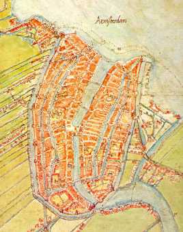
Art of Mapmaking & High TreasonJacob van Deventer was a gifted mapmaker who in the period between 1557-1573 drew about 250 maps for Philips II, by the Grace of God King of Spain and also King of the Netherlandish Provinces.
Below is Jacob van Deventer's map of Amsterdam. Van Deventer's maps have miraculously been safeguarded for prosperity and they show the towns of the early Netherlands in a documentary way. Making this region into one of the best early mapped regions in the world. Below is the map of Amsterdam which around 1560 was only a small town, showing none of the signs of its future glory and importance. Town archaeologists generally love Jacob van Deventer's maps because of his precision and immaculate detail.
These 250 maps were intended for use by the Military forces of Spain. Spain was having a hard time at that moment to keep the populatrion of The Netherlands under control. Religious dissent and uprisings abounded. Soon the War would break out, lasting from 1568 to 1648, the Eighty Years War. In 1648 however the Republic of the 7 United Provinces emerged victorious. The King held on to the southern provinces which remained Roman Catholic.
See Amsterdam in 1842 (Map with dots)
The Amsterdam in 1560 map shown below is in collection of State Archive, North Holland, (43 x 35 cm, see detail). North is on top.